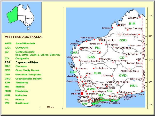
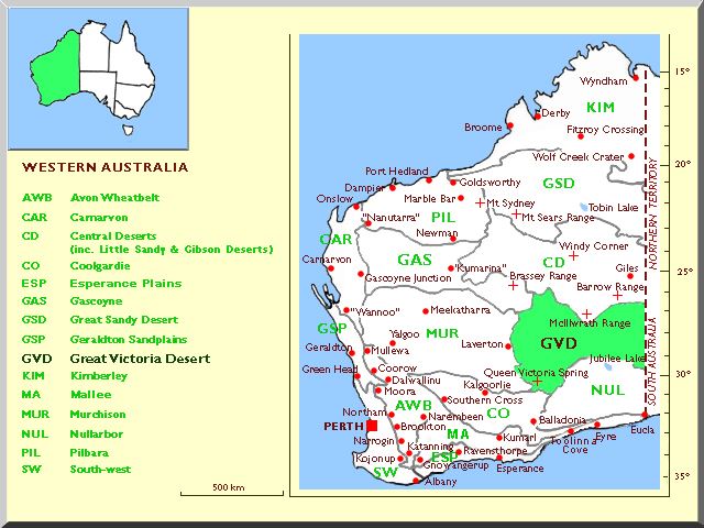
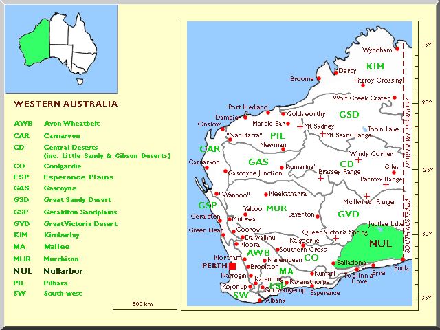
The states of this Character are based on the Interim Biogeographic Regionalisation for Australia (IBRA) scheme proposed by Thackway and Cresswell (1995) but with some neighbouring regions amalgamated, forced by the Lucid software limit of fifteen states per character. Consequently North Kimberley, Central Kimberley, Dampierland, Victoria Bonaparte and Ord Victoria Plain have been united as Kimberley, Tanami has been included in Great Sandy Desert, Yalgoo included in Murchison, the three regions Little Sandy Desert, Gibson Desert and Central Ranges have been united and called Central Deserts, whilst the regions Swan Coastal Plain, Jarrah Forest and Warren are united and called South-west.
The maps used to illustrate our adaptation of the IBRA regions are based on those published initially by Maslin (2001), WATTLE - Acacias of Australia, and later by Brooker et al (2002), EUCLID: Eucalypts of Southern Australia (edition 2).
The botanical region characters should be used carefully. If a specimen comes from near the boundary between two or more regions, select several regions to allow for range extensions or geographic imprecision.
Distribution data for this character were derived from Paczkowska & Chapman (2000) The Western Australian Flora - A Descriptive Catalogue and from the Australian National Herbarium specimen database.
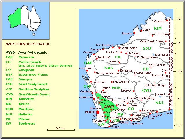
Avon Wheatbelt
Covers the gently undulating western and northern wheatbelt regions of inland south-west Western Australia from Mullewa south to Katanning and Narembeen. Originally mixed eucalypt woodlands and scrub heath, now much altered by agriculture.
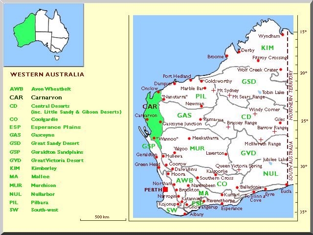
Carnarvon
Arid country with a mosaic of saline alluvial plains, sandy plains and dunes, and clay flats in coastal and near-coastal areas of central-west Western Australia from the eastern shore of Shark Bay north to Onslow and including the lower Gascoyne and Ashburton Rivers.
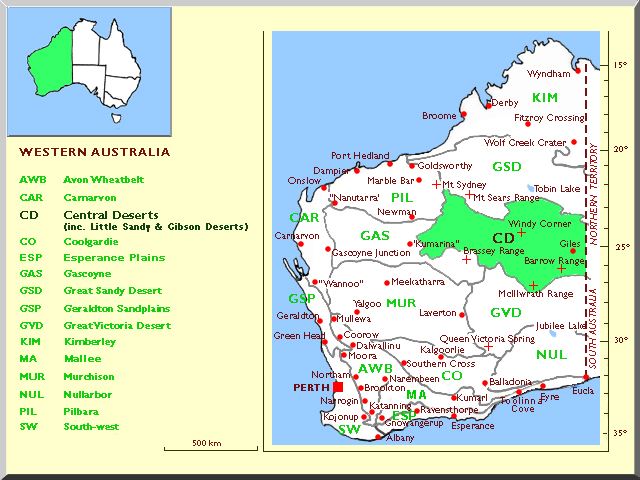
Central Deserts (including Little Sandy & Gibson Deserts)
As defined here this arid area includes the following three IBRA regions: Little Sandy Desert, Gibson Desert and Central Ranges. The Little Sandy Desert is an area of dunes and isolated sandstone ranges. The Gibson Desert comprise lateritic uplands, dunes, sandplain and buckshot plains. The Central Ranges is a region of lateritised sandstone plains and proterozoic ranges, interspersed with sandplains and dunes, of east-central inland Western Australia.
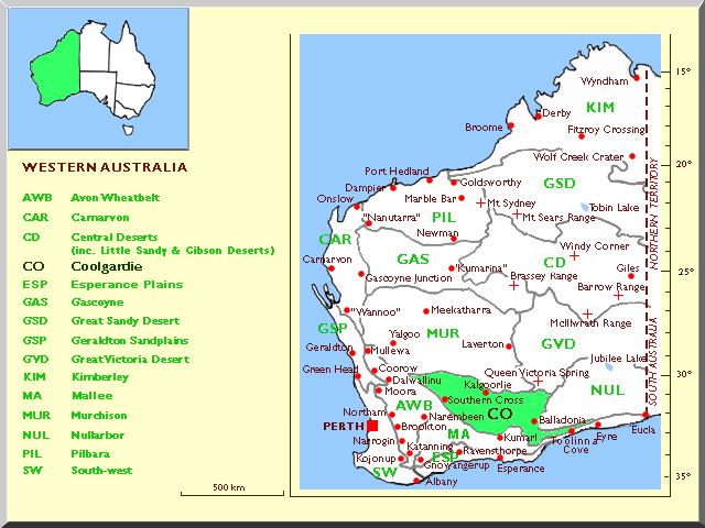
Coolgardie
The arid/semi-arid granite/greenstone belt of the "Goldfields region" in inland south-west Western Australia. Rich in endemic eucalypts in mallee and low woodlands on greenstone hills, valley alluvials, calcareous plains, sandplains, laterized uplands, granite outcrops and around salt lakes.
Esperance Plains
Covers the southern coastal sandplain strip from approximately Cape Riche (just west of Bremer Bay), eastwards through Ravensthorpe and Esperance to where the Wylie Scarp meets the coast just west of Toolina Cove. There are occasional granite outcrops and quartzite ranges. Vegetation is a variety of scrubs and mallee heaths. The Stirling Ranges are in the extreme west of this region.
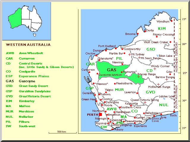
Gascoyne
Arid lands with low sedimentary granitic ranges and broad valleys draining the upper Gascoyne and Ashburton River catchments and largely covered with Mulga woodland and scrub on hard shallow earthy loam or stony loam in central-west Western Australia.
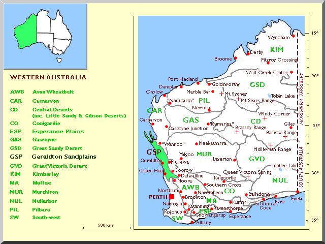
Geraldton Sandplains
Covers the semi-arid scrub-heath and open woodlands of the Indian Ocean coastal and near-coastal region of Western Australia north from Greenhead through Geraldton and Kalbarri to Shark Bay.
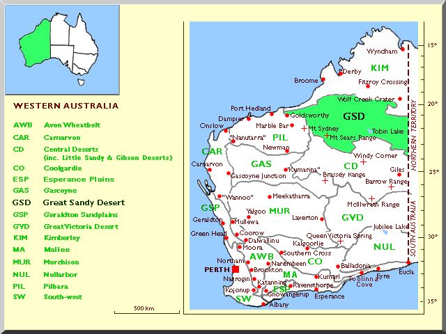
Great Sandy Desert
Extensive arid hummock grasslands with scattered trees and shrubs on longitudinal dune-fields over sandstones. Extends from east of Port Hedland into the Northern Territory. As used here this bioregion includes that part of the IBRA region Tanami which extends into Western Australia south and south-east of Halls Creek.
Great Victoria Desert
Sand-ridge desert in south-central Western Australia, from east of Laverton to and beyond the South Australian border.
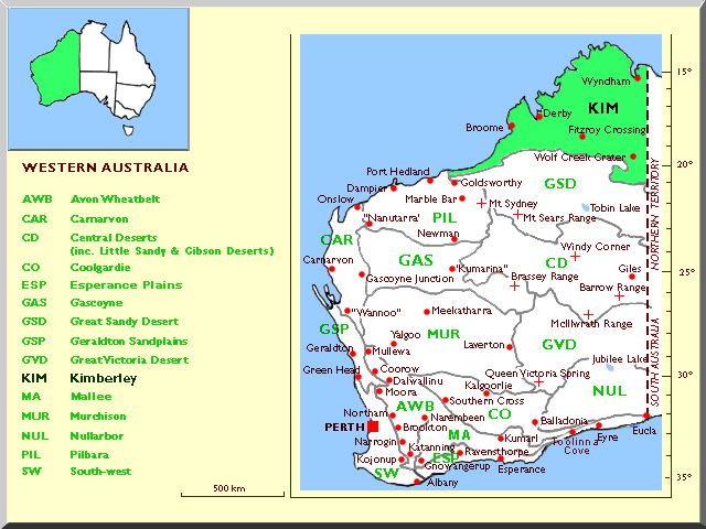
Kimberley
The tropical north of Western Australia, a combination of five IBRA regions, viz. North Kimberley, Central Kimberley, Dampierland, and parts of Victoria Bonaparte and Ord Victoria Plain. Wet in summer and arid in winter. A complex of plateaus, escarpments, mountain ranges, plains and broad river valleys. The vegetation is correspondingly complex with eucalypt woodlands, pandan and cajeput riparian woodland, tall grasslands and hummock grasslands.
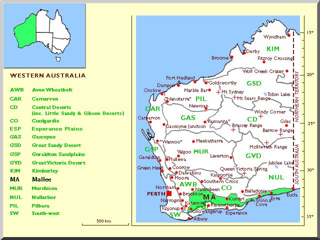
Mallee
Covers the gently undulating southern wheatbelt, the mallee and woodland areas south of Forrestania and Salmon Gums Mount Ragged, and includes the IBRA region Hampton, which is an arid coastal sand strip, limestone escarpment and plateau from west of Toolina Cove eastwards to the South Australian border. A very diverse area for mallee and woodland eucalypts. In the west the region has been considerably modified by agriculture.
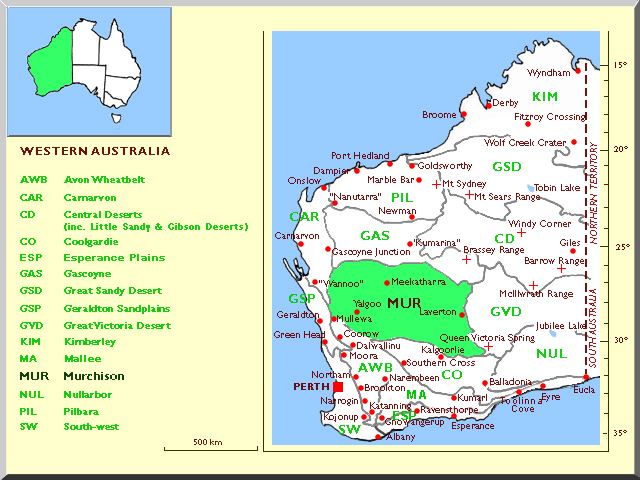
Murchison
Covers the arid Mulga low woodlands, hummock grasslands, Mallee-Mulga over hummock grasslands, saltbush shrublands and saline communities in south-central Western Australia extending from Wannoo east through Meekatharra to Laverton and almost to Kalgoorlie. As defined here this bioregion also includes the IBRA Yalgoo region which is arid to semi-arid with Eucalyptus, Acacia and Callitris low open woodlands.
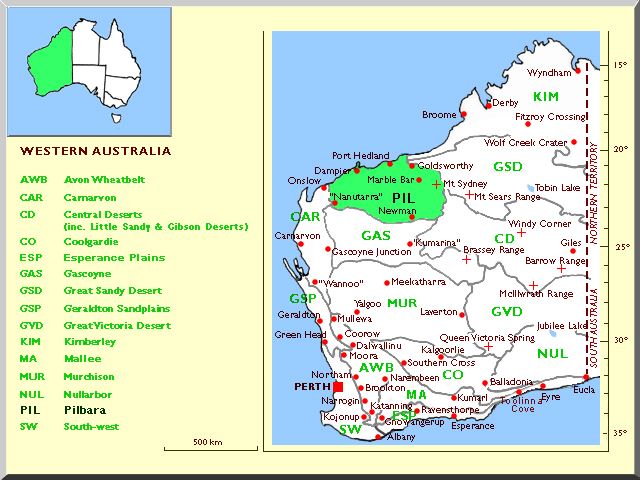
Pilbara
Sub-tropical complex of ironstone mountains and plateaus, alluvial plains, coastal plains and riparian zones. Wet in summer, arid in winter. The vegetation is scattered eucalypt, mulga and other Acacias, with hummock and other grasses and some shrubland.
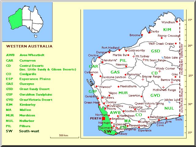
South-western
Covers the temperate eucalypt forest and woodland region of south-west Western Australia. As defined here this bioregion includes the following three IBRA regions: the low-lying sandy Swan Coastal Plain region extending north and south of Perth; the lateritic plateau and ranges of the Jarrah Forest region from Margaret River east to Kojonup and Cape Riche extending north to New Norcia; and the more dissected undulating coastal and subcoastal country of the extreme south from Albany west to Augusta, the Warren region.